
Part two of the story of a walk around the Glasgow Inner Ring Road, my contribution to the Forth World Congress of Psychogeography 2023. For part one, see here.
TWO: From the ski slopes to St Valentine
Where to start? One measures a circle beginning anywhere, as Charles Fort observed. True North or Magnetic North? High noon on the clock face, due east to meet the dawn? Pick a card, any card. For no particular reason, our walk begins in Kingston.
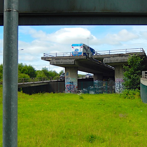
JG Ballard is clearly the presiding genius of our chosen starting point, below the ski slopes at the south-west corner of the ring route. These are the two elevated decks that would have linked the west and south flanks of the GIRR. The truncated lanes, left hanging above a grassed waste ground, are broken promises. Links to a road that was never built, squeezed between the on and off ramps connecting Kingston and the bridge named after this area.
The lines of the two ramps point east, towards Kingston, Laurieston and Gorbals, where another ghost junction was intended to carry ring road traffic north. The decks, as the Pathetic Motorways website points out, are “evidence of the missing plan” while roads.org.uk describes them as “unfinished business on a grand scale”.
Standing below the truncated decks, watched over by Shed Man and the Kingston Car Spa, we’re surrounded by the blown litter and scrub grass of every highway interstice, every lost space disconnected from its surroundings, a cordon insanitaire of tyre dust, tarmac chippings and orphaned diversion signs.
Every interchange has them, every slip road has its intertidal zone, where flotsam and jetsam drift with the currents. Underneath the ski slopes, behind protective barriers, there’s an agglomeration of slabs, cut stone, road menders’ supplies. The supports have a thin coating of wobbly graffiti, amateur daubings, apprentice pieces.
From here, our walk heads east, on a route south of the southern flank, outside the intended artery, to see the sights and sites exiled beyond the ring road, and to view the areas blighted by the threat of the unbuilt section. Where the dashed lines of future development have postponed or curtailed development.
Among car parks and stalled spaces, acre after acre of urban space that no-one would invest in, because one day it might be replaced by a motorway.
Echoes of Empire
The route of the southern flank would have flattened the blocks between Wallace Street and Cook Street, and their continuation as far as Crown Street in Gorbals, almost a mile to the east.
Add in slip roads and other services and some landscaping, and we’re talking a swathe more than two city blocks wide, cutting through Glasgow’s earliest south-side suburbs, creating a barrier – both physical and mental – between the city centre and the periphery.
Walking along Cook Street, into Bedford Street, onto Bedford Lane and Cleland Street, the outlook is the same. Empty lots and abandoned buildings. Low-rent spaces, temporary use, no repairs considered. Waiting for something to happen.
For decades, that something was the southern flank. Now, marching west from Gorbals, comes boxy brick housing, with no shops, pubs, amenities or social spaces. Anonymous machines for living. Modern, efficient, all about interiors. Characterless.
On the south side of Cook Street is a recent housing development called, for no apparent reason, Westbridge Gardens (it’s east of the Kingston Bridge). The scheme incorporates the former Eglinton Engine Works, which made machinery for processing sugar cane, some of which was exported to the Caribbean.
The courtyard of the development features cast iron stanchions that once supported the roofs and travelling cranes of the works. The deep history of Kingston and Tradeston, part of Empire, lingers.
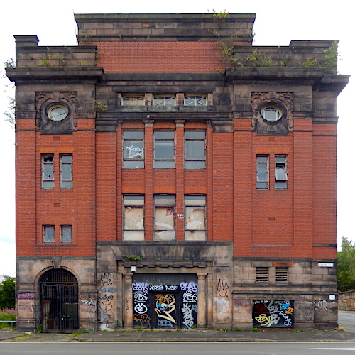
Across the road, the red brick Venetian Gothic grandeur of the Blacklock and McArthur paint factory, surmounted by a crenellated tower, built in 1896 but now a partly-occupied shell, dominates the corner of Cook Street and Tradeston Street. The design, by WF McGibbon, incorporates a stag’s head, the firm’s trademark, on the street corner.
Like others in Glasgow, the building reflected the company’s taste and style, and was part of its marketing. The building is a long-standing entry in the Buildings at Risk Register for Scotland. When I passed, at the side door, a crew of maybe eight men was unloading two white Transit vans onto the pavement. Another crew was moving the assorted cargo from the pavement through a half-open door into the building.
The merchandise, suggestive of disability and disaster, includes walking aids of all sorts, from Zimmer frames to wheeled chairs, and a wide range of large plastic cases labelled “Lothian & Borders Fire Service” and “flood suits”. None of this is new, and has the look of an auction “assorted lot”. The denizens of the paint factory look prepared for any environmental disasters the near future could bring.
Next comes the red brick and blond sandstone Baroque box of the former telephone exchange at 243 Centre Street, built around 1935 and now abandoned. Another long-standing entry in the Buildings at Risk Register, adorned with more uninspired graffiti.
Further along Cook Street, at the corner with Salkeld Street, in the arches below the approaches to Central Station, two unrelated businesses sit in neighbouring units. One offers cylinder heads, the other pizza.
Across the crunchy pavements
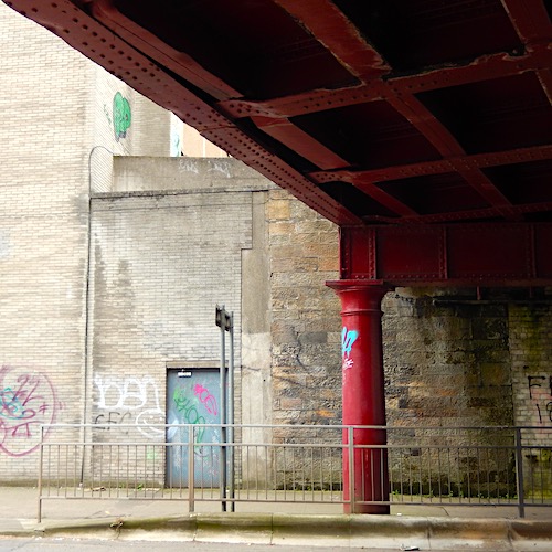
Overhead, the train lines create an east-west barrier between Tradeston and Laurieston. There’s even a road sign announcing the former, as if daring the traveller to go west, under the ill-lit and pigeon-infested cast iron bridges and across the crunchy pavements. The prospect, of litter strewn gutters and abandoned buildings, is not inviting.
A young woman, exiting Bridge Court on the south side of the street, smirks as I take another photograph of the handsome cast iron column supporting the bridge. I worry that she’s got me down as an inferior type of train spotter, a collector of railway industrial heritage. Above the tracks, the former Signalling Centre for Glasgow Central Station greets passengers: Welcome to Glasgow Central.
Leaving the railway arches and bridges behind, there’s more light from the east, as we ease past the Moderne wedding cake of the 02 Academy at 121 Eglinton Street, the former New Bedford Picture House, readying itself for a heavy metal gig – security geeks, articulated lorry, sleeping coach, other vans, early fans – and head into the chunks of engineering brick (north) and brown brick (south) housing.
This in a stone-built city, where brick was reserved for factories and the bin sheds of tenements. To the south of Bedford Street, a wide grassed ditch runs north to south, part of a Sustainable Urban Drainage System (Suds), a recent addition to the landscape of new developments.
The following two streets to the south sport permanent traffic barriers, another recent and less welcome part of new developments, hiving off public space for private benefit. A sprawl of temporary traffic barriers litters the roadway, complete with collapsed road closed and diversion signs.
The brick alley of Bedford Street leads to a welcome survivor, the former British Linen Bank at 162-164 Gorbals Street, designed by James Salmon Junior in 1897 in the Glasgow Style, the local expression of Art Nouveau. The bank has been converted to retail use, and the three floors of apartments above renovated.
The gable end of the building has been clad in Corten steel, with a banal quote from James Salmon cut into the metal: “The art in a building would always reflect that period or movement in the continuum of time when it was conceived and realised.” Opposite the bank, a tall stalk holds aloft the mobile phone transmitters that formerly stood on the lost Norfolk Court multi-storey flats.
The bones of St Valentine
Another elevated railway line provides more arches for intrepid businesses and community use. Cleland Lane South features a series of storage spaces for local groups, one showcasing an upright fridge-freezer with a Palestinian flag strapped to its side. The Gorbals Men’s Shed occupies an arch, and another shouts “NO FIREWORKS” for fear of disturbing the pipistrelle bats in their brick caves.
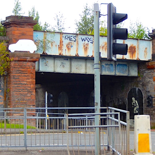
The attached railway bridge gives a roof to this part of Cleland Street, and the niches in the supporting walls pay homage to three figures from the local streets. Hannah Frank (artist, born South Portland Street), Allan Pinkerton (private eye, born Muirhead Street) and Benny Lynch (boxer, born Florence Street). They seem beacons of the past, the erased Gorbals, that notorious slum district, not part of the new redrawn street patterns, brick not stone housing, half the space given to cars, all leavened with thick gobs of public art.
Above the eastern entrance to the arch, a car-shaped sign has evidently lost its lettering and stands, bleached and blank, silhouetted against the dirty red sandstone of the abutment.
Then a surprise: a short stretch of dual carriageway, fitting the curve of the planned GIRR, sweeping travellers through 90 degrees along the realigned Laurieston Road. The planned arc would have linked the south and east flanks of the ring road, taking the route over the River Clyde.
The bend features a very defensive curved building, coppery metal cladding above orange tile, with no windows or identifying marks. Following the facade to the east reveals it to be Gorbals Parish Church, the local outpost of the Church of Scotland, turning its back to the traffic. The curve is sandwiched between St Luke’s Terrace and St Ninian’s Terrace, both new creations and named after demolished churches. Neither meets the usual definition of a terrace.
On the southern side, near the junction with Old Rutherglen Road, a new building features an early wire sculpture of a welder by Andy Scott. A short walk to the east, the Blessed John Duns Scotus church has a wooden box in which, it is claimed, lie the bones of St Valentine.
The bowed dual carriageway marks the end of the southern flank, which has been a depressing walk, bleak and unpeopled, at least until the shops and library near the kirk. All of it within spitting distance of the River Clyde, but with very little life.
In the west, wide-open abandoned spaces; in the east, brick block housing schemes. Unpeopled wastelands, where the car is king. The phantom motorway route is currently resting, full of stalled spaces, temporary or ad hoc rented spaces in significant buildings, unrepaired and decaying.
[Continue reading ‘Ringing the changes’ here]
This piece was selected to be part of the Fourth World Congress of Psychogeography. The postcard, and a short presentation describing the walk, was featured in the finale on Saturday 9 September 2023.