
Part three of the story of a walk around the Glasgow Inner Ring Road, my contribution to the Fourth World Congress of Psychogeography 2023. For part one, see here.
THREE: Along the city’s ancient backbone
The proposed eastern flank began at the curved carriageway, passed along the east side of Crown Street and crossed the River Clyde in the space between the Albert Bridge and the Pipe Bridge and Weir, above the current outflow of the Molendinar, the burn that traditionally birthed Glasgow.
North of the river, the motorway would have destroyed the western entrance to Glasgow Green, and ruined the east side of the historic Saltmarket (remember Sir Walter Scott and “A’ the comforts o’ the Saut mearcat”?), rising to soar over the railway lines south and east of Glasgow Cross.
In terms of individual buildings, the elevated structure would have overshadowed the High Court building, removed the former Central Police Office, and disfigured the setting of St Andrews in the Square, the city’s oldest post-Reformation church.
Our walk begins at what would have been a significant junction, where the curved dual carriageway now stands. Heading north, we pass the streamlined Florence Street health centre, and cross Albert Bridge, just west of where the GIRR would have spanned the Clyde.
From the bridge, the view upriver includes the tidal weir, which controls the water level upstream, and keeps a steady pressure of water on the banks, which would otherwise slip into the Clyde. A breach of the weir in 2017 proved its value.
Walking along the edge of Glasgow Green, the city’s oldest green space, I spot a new Wee Forest, a compact plantation of 600 Scottish native trees, apparently inspired by Akira Miyawaki, a Japanese botanist.
According to the cheery signpost, the greenery “helps deal with the effects of climate change, supports urban wildlife and provides a place where you can experience nature”. So, a small public park, sited helpfully in a large public park.
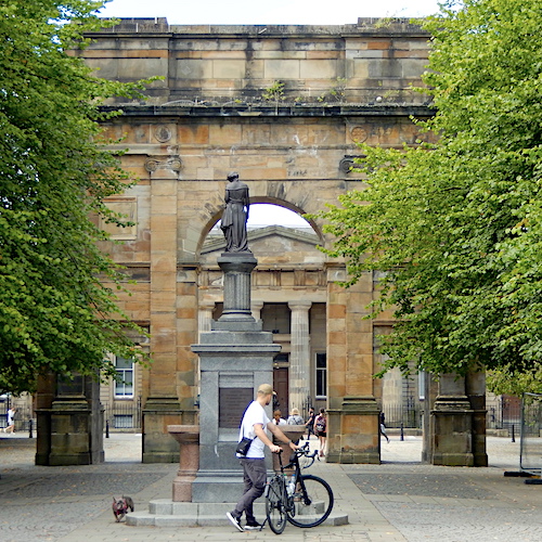
Close by is the McLennan Arch, which lies on the centre line of the proposed motorway, giving an idea of the potential destruction caused by a high-level highway crashing through this historic district. At the time when the ring road was a possibility, the Roman triumphal arch stood at the foot of Charlotte Street; it was moved to its present position at the western entrance to the green in 1991.
The arch, probably Glasgow’s most travelled structure, began life as part of the facade of the Assembly Rooms in Ingram Street, designed by Robert Adam and completed in 1796. When the rooms were removed for an extension of the main post office in 1892, Bailie (senior councillor) James McLennan paid for the frontage to be preserved and reconstituted as an archway, at the eastern end of the green, where it stayed until its removal to Charlotte Street in 1922. A roamin’ arch, if you will.
The omphalos of the city
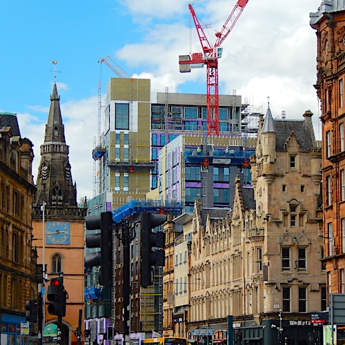
Following the outside of the line of the proposed road, we travel up Turnbull Street to London Road, past St Andrew’s by the Green, built as an Episcopalian church in 1752, Tent Hall, the church-like premises of an evangelical group built in 1876, and St Andrew’s in the Square, built as a Church of Scotland meeting place from 1739. All three have found post-religious uses.
Opposite the third is the former Central Police Office, where women’s suffrage campaigner Emmeline Pankhurst was taken in March 1914 after a rather lively meeting of the Women’s Social and Political Union in St Andrew’s Halls. From the top of Turnbull Street we can see Glasgow Cross, where the 126-foot-tall Tolbooth Steeple stands like a lighthouse on its lonely traffic island, having survived the demolition of the original 1626 Tolbooth to the west and its 1816 replacement.
At Glasgow Cross, the omphalos of the city, the concretes decks would have soared over the historic junction at a height of 70 feet, almost as high as the Tolbooth Steeple, which is 126 feet tall. North of the cross, the GIRR would have destroyed all the buildings along the ancient backbone of the city.
Walking the eastern flank today, it’s striking how quickly the city centre fades to the east, despite the Merchant City gentrification of the former market district. From George Square to the east, the heat map of busy shops and trendy restaurants cools quickly after Albion Street, and High Street itself is a parade of apparently low-rent shops clearly beyond the periphery of the Golden Z shopping district. It’s more like the Main Street of a run-down town in the post industrial hinterland.
North of the cross, and keeping to the east of the planned road route, we encounter a recent upmarket housing project in a converted street cleansing depot. This block, on Bell Street at the corner with Watson Street, was built by Glasgow Corporation in the days of horse drawn vehicles. Carts were stored on the ground floor, staff quarters were on the first floor and the remaining two floors were given over to stables for horses, who found their way from street level to their own stalls by ramp. The building was, it has been said, a multi-storey horse park. The ramp has been retained, presumably for the use of those travelling to work by electric scooter.
Ghost lanes of Townhead

Our route takes us through the former College Street Goods Station (Glasgow & South Western Railway Company, 1883), now housing, and even more formerly the site of the University of Glasgow between 1563 and 1870. North of the railway line, we see the former High Street Goods Station (North British Railway Company, 1904), now a mixture of office, hotel, student accommodation and car park blocks set along the newly re-established Havannah Street.
The developer has apparently consulted old maps and recycled the street name on roughly the same route. What they have not done is looked at any historical texts. For example, Dr Archibald Brown, a district surgeon, reported in 1843 that 54 Havannah Street “is almost filled with thieves and prostitutes; so notoriously [sic] is it that it is known throughout the city by the appellation of the Walls of Troy”. Number 64, he added, “is not surpassed by any close in the city for filth, misery, crime and disease”.
On the west side of High Street, only the former British Linen Bank on the corner of Nicholas Street remains in a large city block awaiting a new use. The bank, another fixture on the Buildings at Risk Register, was designed by William Forrest Salmon of James Salmon & Son and completed in 1985. It features a banking hall with a separate rear shop on the ground floor, and two flats above. A sailing ship, symbol of the bank, appears in a stained glass roundel above the door, and a series of putti adorns the window case. Aloft, Athena, goddess of weaving and other crafts, vies for attention with a tempieto or open cupola.
After George Street, the motorway would have headed in a straight line headed north-north-east, on the west side of the curve of High Street. Our route follows the curve, past the (modern) Cathedral Meadow, the (Victorian) Cathedral Square and the (ancient) Cathedral. But we begin with a car park, the epitome of transient land use. This is the first of a half-mile-long chain of car parks on the proposed route.
To the north, the modern map reveals student residences for the University of Strathclyde. The Student Village, centred on the Lord Todd building, has taken advantage of the planning uncertainty on the hill to create a settlement for the unsettled. Then come the council car parks, strung out like washing on a line: one behind the Barony Halls, three in a row along Castle Street and Glebe Street, and a fifth one north of Glebe Street. Together, they are a perfect example of the term Grey Belt, coined by town planners to describe scrub land and car parks overlooked or left behind by development, yet within easy reach of amenities and transport.
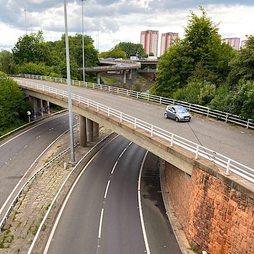
Just south of Townhead Cross, still marked on the map but with nothing on the ground to suggest a crossroads, we can ascend to a pedestrian crossing, strung like a high wire over the A803, and look over the on- and off-ramps connecting the motorway interchange and the street-level road system. Two ghost lanes indicate the planned line of the eastern flank, an eerie echo of the two ski-jumps at the diagonally opposite corner of the ring road.
The abandoned lanes stop abruptly, and the two replacements veer to the west. The author of the Pathetic Motorways website notes the vestigial “right-hand entry and exit pair” of the original plans for Townhead Interchange. The website adds that “the main route would have been continuous around the Ring Road at that point, which is why the slip-roads are so huge, and half-stretched out”. The author continues: “You can really tell what’s going on [with the planned route] by following them. They suddenly come to a crashing halt, and hit a set of off-set traffic lights.”
The road layout at this point, including the truncated link roads, certainly has an unfinished, provisional feel to it. The entire area south of the interchange, in fact, seems transitional. The authors of the Scottish Roads Archive add: “One curious impact of the cancellation of the east flank is that temporary connections to Castle Street and Stirling Road remain in place after almost 40 years.”
Along the negative ley
To the west, a wooded area screens the interchange from the former Martyrs School (designed by Charles Rennie Mackintosh), and the current St Mungo’s Church and St Mungo’s Primary School. The modern map suggests a plethora of unused space, again the result of planning uncertainties.
The eastern flank, tearing through the ancient streetscapes and Victorian structures of old Glasgow, would have been the most destructive. Even the threat of it has blighted the district, and the route is dispiriting.
The small number of tourist hotspots in the historic quarter – Cathedral, St Mungo Museum, Provand’s Lordship, Glasgow Necropolis – are probably still recovering from Covid, and the middle two from council austerity cuts in opening hours and facilities.
Even Provand’s Lordship, with its bright new Caramac coloured coating, seems a bit lost. Still, there’s plenty of places to park along the negative ley of the unbuilt motorway.
[Continue reading ‘Ringing the changes’ here]
This piece was selected to be part of the Fourth World Congress of Psychogeography. The postcard, and a short presentation describing the walk, was featured in the finale on Saturday 9 September 2023.