
Part four of the story of a walk around the Glasgow Inner Ring Road, my contribution to the Fourth World Congress of Psychogeography 2023. For part one, see here.
FOUR: From Club Concrète to the dragon
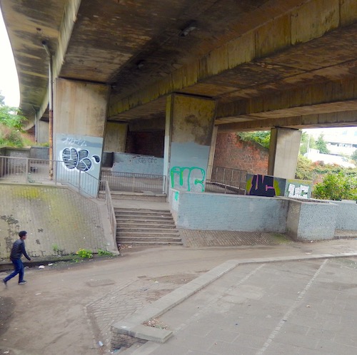
Our walk along the northern flank begins in Castle Street, at the high-wire footbridge that links Parson Street and the Royal Infirmary. From the bridge, a spur heads north, leading past an area I call the lounge or nightclub. This was, as far as I can gather, intended as a social space for those making the journey below the interchange.
It has structures and levels reminiscent of a nightclub seen during the day, when the magic has fled and only the shapes remain. There are what appear to be serving areas, a space for performing or dancing, and platforms for seating.
As well as concrete, some matching grey brick and repurposed cobbles have been pressed into service. It’s as if someone has coated the interior of a nightclub with concrete, then taken the walls away. A few battered signs suggest someone has taken the same view: “The Underpass is the site of a speculative design project which seeks to reimagine overlooked urban spaces.”
Club Concrète was the scene of a short ceremony during my Terminalia walk along the old burgh boundary of Glasgow in February 2019. We had a short reading from Ovid, made offerings of corn (tinned sweetcorn), honey (honey-flavoured peanuts) and wine (a very small bottle of Aldi red), and sacrificed a lamb (an early Easter chocolate figure) to Terminus, the Roman god of boundaries and good neighbours. Even then, it didn’t feel like a nightclub.
Overall, the built motorway has acted as a tarmac curtain, restricting economic and cultural activity to the north of the city centre. The unbuilt half of the GIRR, meanwhile, has cast a decades-long shadow over possible development along a wide corridor that should have been the next concentric tree-ring of the city’s growth.
From the Rusty Bridge to the Giant Flowers (roughly Junctions 15 to 17) the motorway presents an impenetrable barrier to north-south pedestrian and cycle journeys. Only the road linking Craighall Road and Dobbie’s Loan (the A879), close to the potential link to the proposed Maryhill Motorway, pierces the barrier. But it’s a confusing and hostile interchange for cyclists and pedestrians. Not for the first time, I’m reminded of George Orwell’s slogan in Animal Farm, or at least a variant on it: Four wheels good, two wheels bad.
Dust from the coal canal
Townhead Interchange, of which the concrete nightclub is a constituent, is described by the Scottish Roads Archive as “a sprawling, complex interchange”. However, it notes: “Clever landscaping and the compact, two-level design ensures Townhead Interchange remains relatively unobtrusive given its size, importance and complexity.”
That might be true for the motorist, but the pedestrian experience is very different. Nevertheless, the archive insists that “it was recognised that community severance could blight the local neighbourhood” and so “a network of pedestrian overbridges, underpasses and walkways were incorporated within the project from an early stage”.
Again, that’s not how it feels on the ground. Additionally, some of the embankments of the interchange have been clad with red sandstone, reputedly salvaged from the demolished tenements of Townhead. Which is possibly adding insult to injury.
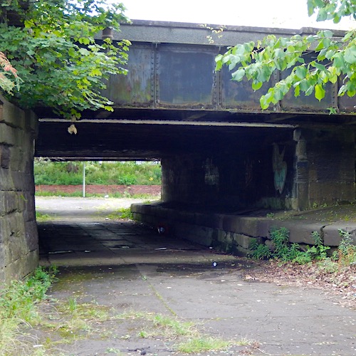
Moving on, we see that the section of Castle Street between Townhead Cross and Pinkston Road passes over two on- and off-ramps and then under the thundering highway of the M8. Just before the junction, though, we can visit a remnant of another transport route, mostly erased by the M8 to the east of the city, that runs below the street.
Here, a short tunnel carried the Cut of Junction linking the Townhead terminus of the Monkland Canal to the Glasgow branch of the Forth & Clyde Canal, and the outlines of the channel and towpath are visible. Cast iron plates, to protect the stonework from erosion by tow ropes, are themselves grooved.
Ground levels have changed, and the channel is dry, but it’s still possible to imagine barges being hauled along the canal, which ran 12.25 miles from Calderbank near Airdrie to Townhead Basin, on the east side of Castle Street (just north of the Macewen Building of Glasgow Royal Infirmary), bringing coal from Lanarkshire for the industries and hearths of Glasgow.
Around the stone circle
North of Baird Street, at the east side of the police station, a luxuriant forest of wooded greenery appears, as if the interchange is set in the middle of a soundproofed and soothing ancient woodland. Once on the path along the northern flank, we soon pass an attenuation pond connected with the local Suds.
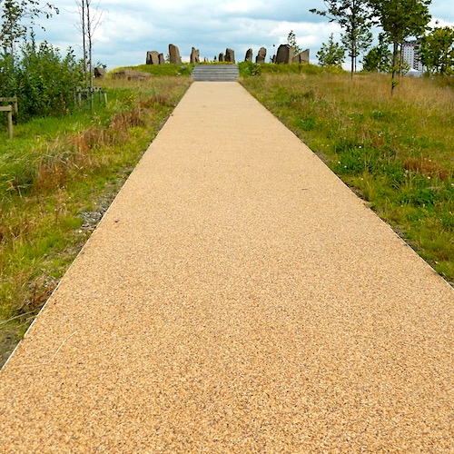
The path, looking like a neatly-cut strip of sandpaper, progresses through wildflower-strewn grass to the stone circle at Sighthill, its gaunt verticals echoed in the tower blocks to the north and the obelisks of Sighthill Cemetery.
The stones stand sentinel on an artificial mound circumscribed by the M8, Pinkston Road and new vertical housing. The circle, which previously occupied a windswept corner of Sighthill Park (itself removed to another part of the rebuilt district), is a remarkable artwork devised by Duncan Lunan and first completed in 1979.
During the sweeping redevelopment of the entire Sighthill district, the circle was moved and realigned in 2019. It has been hailed as the first astronomically-aligned stone circle constructed in these islands for 3,000 years.
Next comes the curved shell of a pre-rusted bridge: the Sighthill Footbridge, officially, but locally the Rusty Brig. A statement piece to replace an outdated concrete ribbon, landscaped at the southern end and looking like the shed exoskeleton of some oversized insect.
The staircase at the southern end of the bridge was hailed as the largest 3-D printed structure in the United Kingdom, and the first printed concrete structure in Scotland. It rises in stages through terraced gardens, from street level to bridge level, with a cycle path on a looped gradient to the west.
After a long thin basin of water, lined with concrete and replete with water lilies, comes a narrow, muddy and overgrown path a few feet from the motorway, overhung with overgrown greenery.
The darkest places in the environs of the motorway aren’t the concrete canyons but the leafy walkways, carelessly positioned out of sight of any nearby houses or offices, and where any screams are drowned by traffic noise. They twist and turn, so there’s no clear line of sight to the next main road or open space.
In the novel Concrete Island, JG Ballard mused that a car driver crashing through a motorway barrier could find himself a castaway on a concrete sea. Pedestrians, I would suggest, have it worse. A twisted ankle, a mugger’s punch or a dizzy turn could leave you stranded in muddy undergrowth, up to your ankles in black ooze and any help securely behind a metal fence and 80 to 90 decibels of fast traffic noise. Summer may bring more light, but there’s more tree cover. In the winter dark and damp, this would be a perfect folk horror setting.
While pedestrians are struggling through the mud, drivers can spot a vestigial connection to an unbuilt motorway. Between Junctions 16 and 17 is the unfinished connection with the proposed Maryhill Motorway. Both the east and west bound carriageways “would have had an exit to the Maryhill Motorway at a lower level before climbing uphill to merge with an entry slip-road”, according to roads.org.uk.
Those heading west on the M8, that website adds, will see that “the exit slip-road is particularly prominent as more than a stub – it’s a short section of surfaced carriageway that passes under the eastbound carriageway before stopping abruptly”. The Scottish Roads Archive also mentions “this ghost junction” and describes the “intended connections and slip roads” here.
These were incorporated into the construction of the road “to reduce the impact on traffic when construction of the Maryhill Motorway took place” under Target Two. The authors of the archive add: “The unused stub is a visible reminder that the city had a much larger motorway plan.”
Here be a dragon
Then our route passes part of the Port Dundas canal complex, including the recent basin at the side of the M8, and climbs up towards Speirs Wharf, and down past Civic House, former home of the Civic Press, a left-wing printer that produced election posters, leaflets and placards. Probably the most important of its productions was “The Scottish Worker”, published daily by the Scottish Trades Union Congress during the General Strike of 1926, principally to counter anti-strike propaganda.
Nearby, a footbridge carries us over Garscube Road. All around, the Woodside Viaducts, including Junctions 16 (Craighall) and 17 (St George’s Cross), are currently being repaired, causing disruption at Charing Cross and St George’s Cross. The work has been going on since 2021, and is expected to continue for years.
The footbridge now leads to a temporary path alongside some serious heavy engineering, jacking up and strengthening the viaducts that support the M8 around the north-west corner of the ring road. The walk back to St George’s Cross takes us past the distinctive architecture of the former Woolworth’s store in New City Road, now a Muslim cultural and social centre called Andalus, and to the sainted George himself.
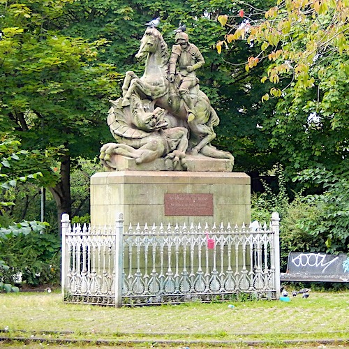
The statue of St George, complete with dragon and attendant pigeons, once stood on the parapet of the St George’s Cross Co-op Society premises on the corner of St George’s Road and Gladstone Road.
When this was demolished in 1985, the stonework was rescued and placed on top of a plinth in a small tree-lined park. The statue, carved by J&G Mossman in 1897, shows St George, on a horse and in a full suit of armour, thrusting a lance into the mouth of the dragon, which grips the plinth with its claws.
Incidentally, there’s another co-op at the end of this section of the walk, the former headquarters of the Scottish Co-operative Wholesale Society. And the remains of St Valentine at the opposite corner of the ring.
[Continue reading ‘Ringing the changes’ here]
This piece was selected to be part of the Fourth World Congress of Psychogeography. The postcard, and a short presentation describing the walk, was featured in the finale on Saturday 9 September 2023.